Superior Hiking Trail Highway 301 to Tettegouche - Fall 2023

Bean Lake from the Bean/Bear Lake loop, Tettegouche State Park - Silver Bay, MN
It was time. Time to visit the blue blazes again. Time to get my pack on my back again. Time to power off and unplug for awhile. It was time to return to the Superior Hiking Trail (SHT) on Minnesota’s north shore of Lake Superior for a 5(ish) day, 50-mile backpacking trip. This trip covered most of map section C on the official SHT maps, from County 301/Fors Road to Tettegouche State Park trailhead.
Day 1 - October 2nd, 2023
Campsite: Crow Valley
I elected to have a little bit of a later start with my shuttle booking, I drove up to Tettegouche State Park on Monday morning, and my shuttle picked me up shortly after noon for the ride south. Overnight and longer-term parking is available at Minnesota state parks with a valid park sticker, but you must check-in at the office to register your vehicle and get directions on where to park. I booked my shuttle with Superior Shuttle, and once again, I was very impressed with their service and had a wonderful conversation with the shuttle driver on the ride south.
I got on trail just before 1:30PM, and within a few minutes I was back in the northwoods, hiking away from the noise and traffic of highway 61. I stopped briefly at the overlook where I lost my tarp last year (see my blog post here for more on that debacle).

My day was pretty low mileage (only 7ish miles) since I got a late start, but I rolled into camp just before dark. The Crow Valley campsite was a little deceiving on the Avenza Maps, the site was further up the trail than I initially expected based on my location on the map. I had one other hiker that I shared camp with that night, he was headed south to Martin Road near Duluth. I felt like I had all my gear out like a yard sale in camp that night, it takes a couple of days to get my systems back down again. I set up my hammock and then settled down for some spaghetti for dinner (dehydrator recipe here).
Crossing the Encampment River, Silver Creek Township, MN
Day 2
Campsite: Split Rock River Southwest

A little North Shore root beer! Nope, not pollution, but tannins from the conifer trees along the waterways. Nearly all the flowing surface water is this color. I used a Sawyer Squeeze water filter to treat flowing surface water, and the tea color is just a fact of life. :)
The story of the day, mud. Lots and lots of mud. Last year, the new Gooseberry River section of the SHT opened, closing a gap in the trail that had been present since 2015, when the SHTA lost access to a private land parcel near Gooseberry Falls State Park. The new trail segment tags the corner of Gooseberry Falls State Park, and the carries on across public land to the northwest. There are a few slumps along the Gooseberry River, requiring a little careful tread to avoid sliding over the edge. This new segment has a tread that is made up of a clay material, and within a few minutes of starting on it my boots were covered in sticky, heavy mud. The trail was relatively flat with only a few switchbacks to climb down to and back up from a few little creeks along the way. The clay made for some sliding footing heading downhill, but I made really good time cruising along this segment.
The view from near Blueberry Hill on the Superior Hiking Trail, looking back towards Gooseberry Falls State Park.
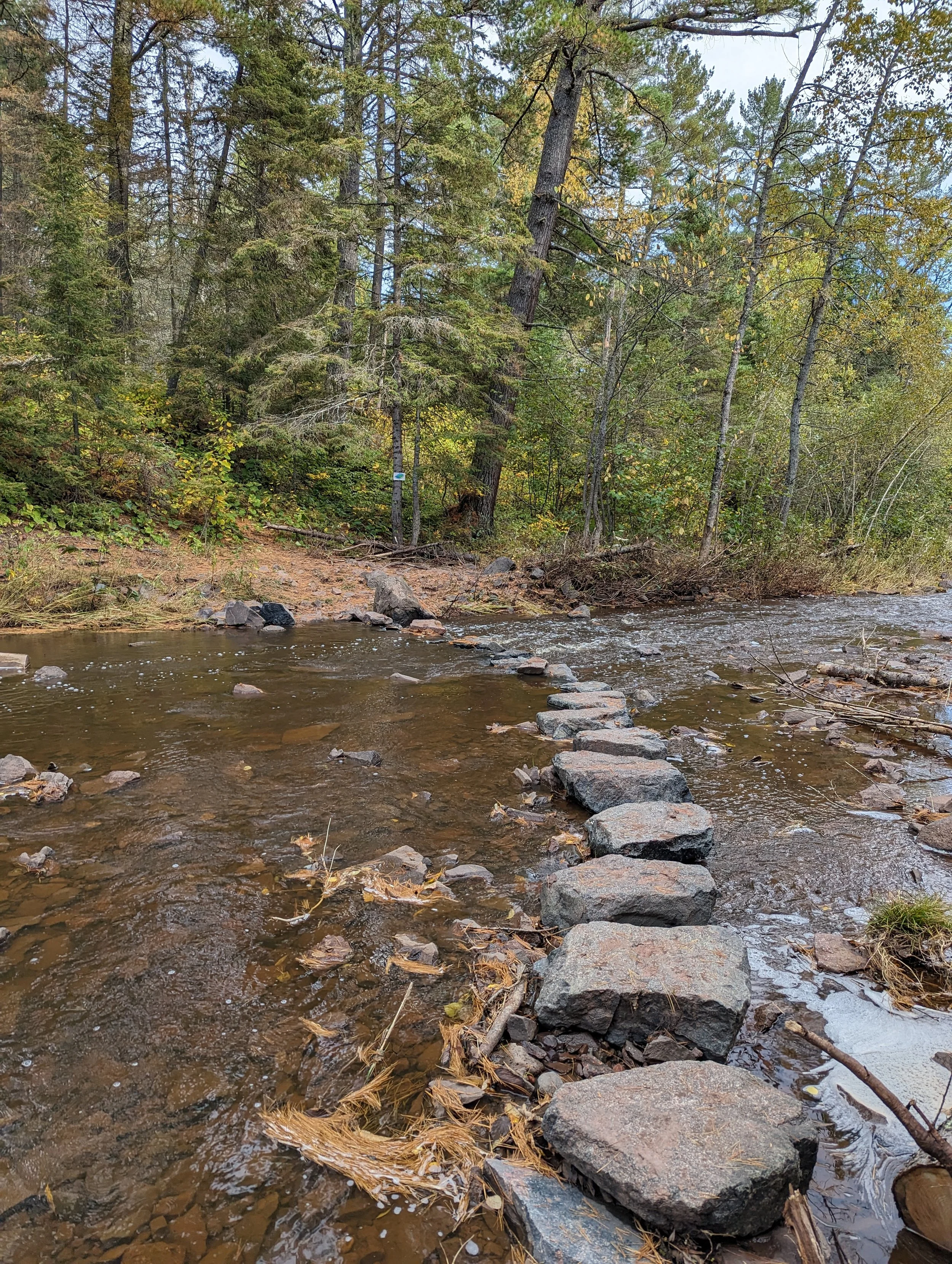
Onward to Split Rock Lighthouse State Park. I asked the southbound hikers that I met about the conditions at the Split Rock River crossing. There have been a number of bridges here over the years, but they have been damaged or destroyed by ice and high water. The crossing location is pretty remote, and with the deluge of rain in the previous weeks leading up to my trip, I was concerned about the water level and if it would be passable. The hikers I talked to had mixed experiences, some forded the river, others took the reroute down to Highway 61. Regardless, I was going to stay at one of the Split Rock sites that evening.
Little did I know, that this section of the trail was one of the more challenging of the trip. The loop trail that follows the river upstream is quite eroded, and often passes right next to the river, which at times is 15-20 feet below the trail. The tread was very muddy, and slippery clay in many places. I slipped and slid my way along, slowly slogging my way through deep mud and standing water along the trail. This segment has seen a lot of traffic, and is on the SHTA’s list for renewal and redesign. Where the trail wasn’t saturated and muddy, there was loose flat rocks that slide around, and made for slow-going. The elevation change along the river reminded me of the trails along the Manitou River in George Crosby Manitou State Park near Finland, MN.

The namesake rocks of the Split Rock River.
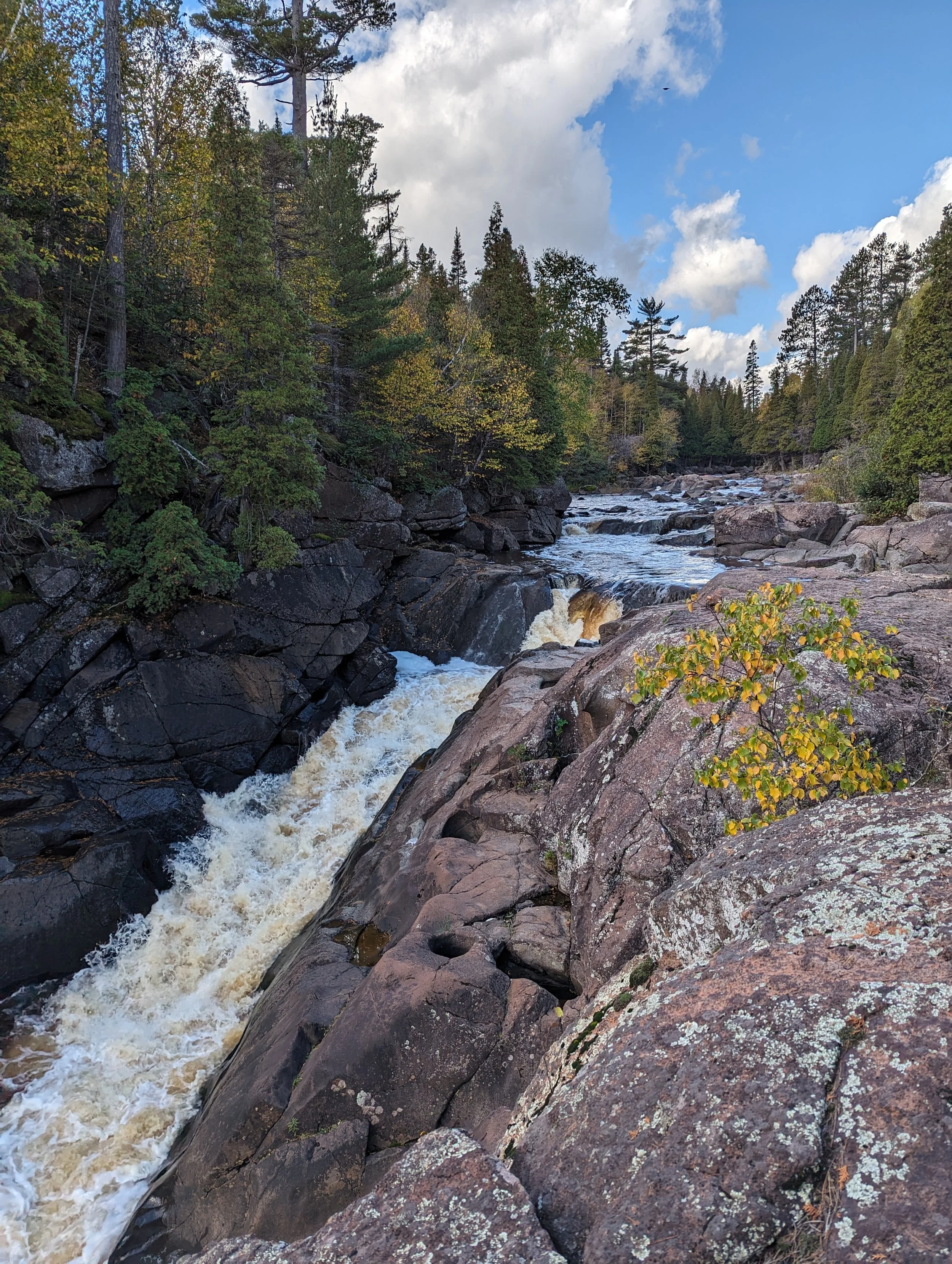
This segment of the trail rewarded me with probably one of my favorite photos from the trip, a small cascade on the Split Rock River.

A small cascade on the Split Rock River.
I finally arrived at my campsite for the night, Southwest Split Rock River. There are four sites along this segment, two on the west side of the river and two on the east side. The site was situated just above the river, and alongside this long cascade, providing a peaceful soundtrack for the night. I elected to stop, and evaluate the river crossing in the morning.

The cascade on the Split Rock River, just below the Southwest Split Rock campsite.
Day 3
Campsite: Fault Line Creek
Day 3 dawned with light rain. I packed away my gear and quickly got back to the trail. I headed up to the river crossing, and stared at the water level. The river was still a little high from the recent rains, and it would be a wet-feet crossing. I decided not to risk the river crossing, especially since I was solo. I turned back and elected to take the alternate route to a bridged crossing below Highway 61. The trail was just as wet, slippery, and muddy as the day before, but the advantage was I was headed downstream, and for the most part, downhill.

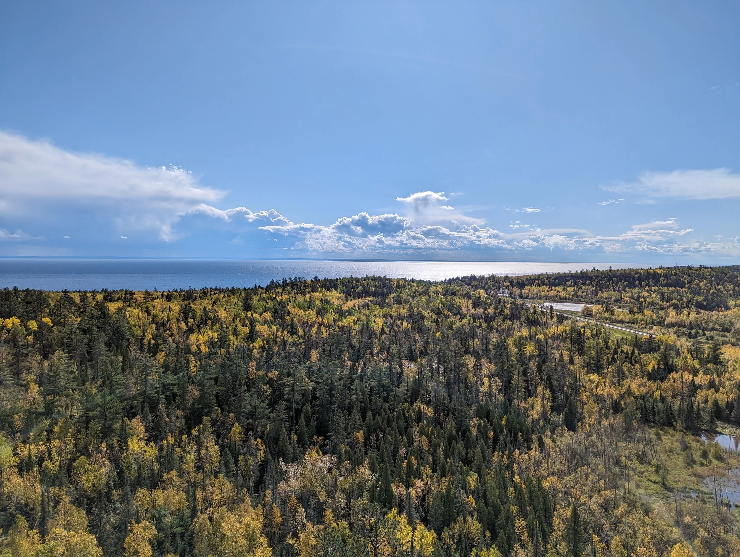
Lake Superior, from the Split Rock River bridge on the North Shore State Trail (NSST).
The alternate route follows the paved Gitchi-Gami State Trail to cross the river, then crosses 61 again, and back into the hills above the lake. The trail overlooks Split Rock Lighthouse and then heads inland.

The view of Split Rock Lighthouse from the Superior Hiking Trail (through my Pixel 7’s telephoto lens).
I met a southbound hiker that had started on the Kekekabic Trail, then the Border Route Trail (BRT) and was completing the Superior Hiking Trail. We chatted for a few minutes about trail conditions and then parted ways, I wished him the best of luck on the rest of his journey.
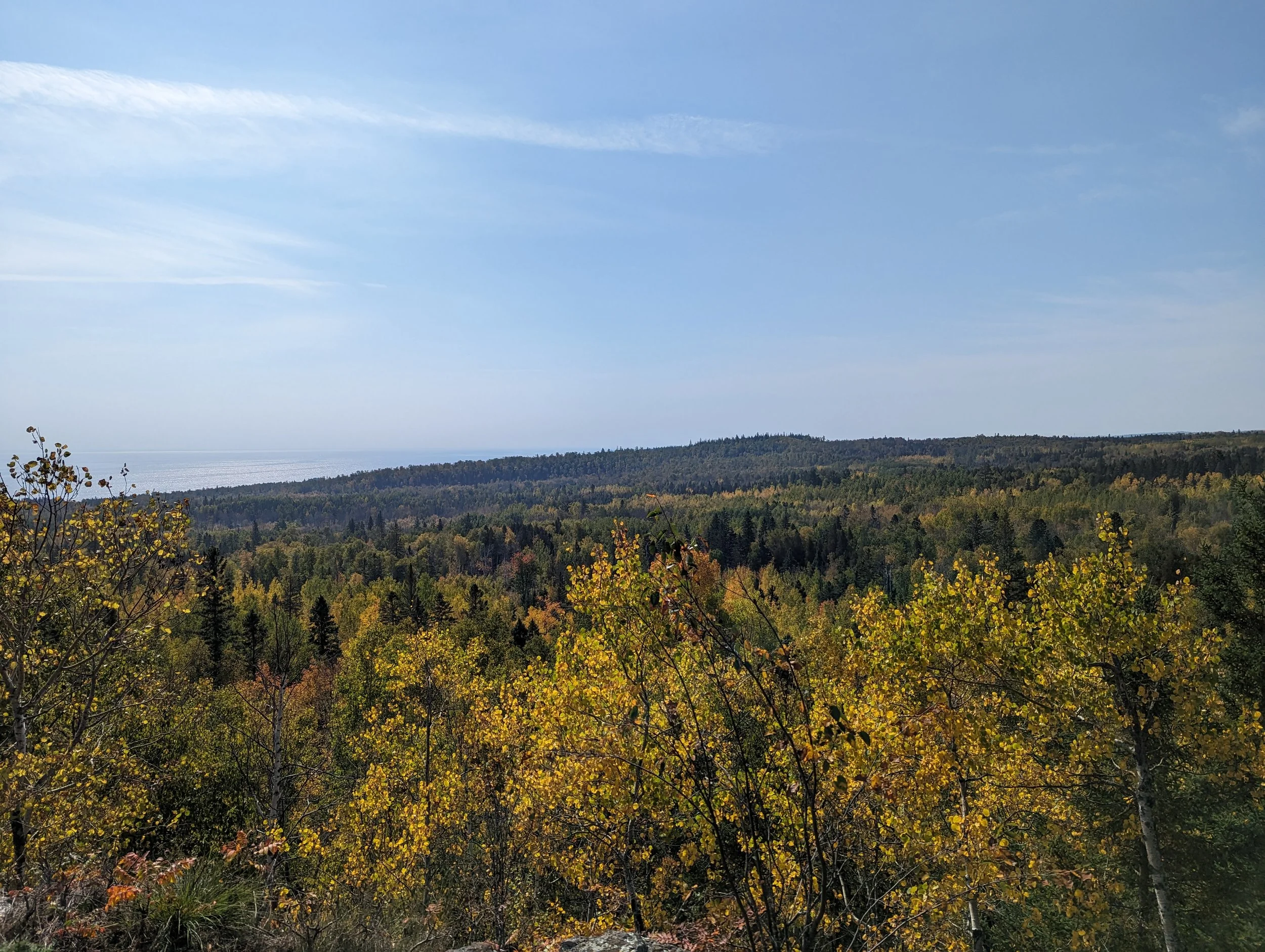
As the trail winds inland, it also climbs up, on the approach to the Sawtooth Mountains. The trail meanders along Chapin’s Ridge, then descends to Chapin’s Creek.

The vista near Chapin’s Ridge campsite, looking over the valley where Chapin’s Creek flows.
Early in the afternoon, a few small rain showers started approaching, but they stayed out over the lake, and I stayed dry. Near the Beaver Pond campsite, there was what appeared to be a puddle in the trail. I’m glad I checked it with my trekking pole before stepping, as this little “puddle” was almost 18” deep. Yikes, that would have been a nasty surprise.

Rain out over Lake Superior, near the Beaver Pond campsite.
The trail intersects with several brand-new mountain bike trails near the Fault Line Creek campsite. I stopped a little early and I parked in my hammock with my Kindle. I’ve been reading the Cork O’Connor series by William Kent Kruger, set in Aurora, Minnesota. If you are in to mysteries and the outdoors, I would highly recommend the series! This campsite was situated below a flight path for what I assume is Duluth International, as there was a fair amount of loud air traffic, but it tapered off in the evening and I didn’t get awoken by it that night. I did wake up in the middle of the night to what I’m fairly certain was a bear moving through the long, dry grass to get to the pond next to the campsite for a drink. It was at a distance, so I didn’t feel the need to make noise and waited a few minutes for it to move along. The next morning, I checked my Ursak, and nothing was disturbed there.
Day 4
Campsite: Penn Creek
Dawn came with a beautiful sunrise. I packed up and started picking my way up the bluffs along Fault Line Creek. This segment had some incredible views, both inland, and towards Lake Superior. I encountered a pair of retired gals on a section hike and we stopped and chatted for a few minutes before moving on.

The beaver pond on Fault Line Creek, right next to the Fault Line Creek campsite.

Looking down the Fault Line valley, several beaver ponds leading down towards Lake Superior.

The vista of the Beaver River valley from the Fault Line cliffs.
After traversing the Fault Line cliffs, the trail drops towards the Beaver River. The trail follows the east bank of the Beaver River, traversing many large rocks, and then climbing towards Silver Bay.
Beaver River, near the South Beaver River campsite.
The trail climbs above Silver Bay, and passes through North Shore Mining property. There are many small overlooks and outcroppings along this segment. I was standing on one of these overlooks when I was surprised by a sudden clap of thunder from behind me. I nearly jumped out of my skin and hurried down off the ridge to get away from the lightning. I just barely got my rain gear out and pack cover on when the skies opened up in a downpour. The icy rain got heavier and heavier, and moments later it started hailing, small pea-sized stones. I stopped near a small creek and waited for the storm to pass. The storm passed quickly, and about 10 minutes later the sun was shining again and reflecting off the hail that covered the ground. A few more showers would pass throughout the day, but that was the last of the lightning and thunder.
The trail climbs above the town of Silver Bay, and then descends to the trailhead at the start of the Bean and Bear Lakes loop.
The view back towards Beaver Bay and Lake Superior
As I crossed at the Silver Bay trailhead, traffic on the trail picked up considerably, which I expected since the Bean & Bear Loop is one of the heavily traveled trails in the fall. A light rain persisted throughout the afternoon. I encountered several families and large groups of folks out for day hikes. I did meet a couple of other backpackers who were headed south to Martin Road near Duluth. The trail was muddy in spots, but for the most part, it was in pretty good condition. I decided to stop at Penn Creek Campsite for the night, rather than push on past Bean and Bear Lakes, and tackle the majority of Tettegouche State Park the next day.
Penn Creek passes right alongside the campsite, and there’s a little waterfall right at the edge of the site. The sign at the spur leading to the campsite says “500 feet to site” but it certainly felt longer than that! Penn Creek camp is unusual, there were two fire rings and benches spread out in the trees, and many, many tent pads scattered throughout. There was even a picnic table, a downright luxury!

The waterfall on Penn Creek, at the edge of the campsite.
Day 5
Campsite: My bed at home :)
Day 5 dawned clear, but I knew more rain was in the forecast. I quickly broke down my hammock and stuffed my pack, ready for the hike through Tettegouche back to my truck at the trailhead. The trail leading up to Bean and Bear Lakes was much more gentle than I expected, and I made good time to the lakes. The lakes definitely live up to their reputations, and it makes sense why they are so popular in the fall.

Bean Lake, Tettegouche State Park.
The clouds had rolled in during the hike up to the lakes, but they parted briefly over Bean Lake. It was early, so there weren’t many folks on the trail yet, and I had the lakes pretty much to myself. As I approached Bear Lake, the wind picked up, and as the morning went on it got stronger and stronger, bringing mist and rain. The hike was still marvelous with the yellows contrasting with the green conifers in the hills.

Bear Lake, foreground, and Bean Lake, background. Tettegouche State Park.
I of course had to take the obligatory photo of Bear and Bean Lakes from the overlook on the northeast end of Bear Lake. There is a SHT campsite on the shore of Bear Lake, but it is not well-suited for hammockers, and tends to be very, very busy in the fall season. I signed the trail register and headed further into Tettegouche.
As I left Bear Lake, the wind really started to pick up, and a mist rolled in. The trail descends toward Palisade Creek, passing Round Mountain, and eventually ascending Mount Trudee. The view of Tettegouche and Micmac Lakes from Mount Trudee just kept getting better and better the further I traveled along the trail. At this point, the wind had kicked up another notch, and I hung back from some of the larger rock outcroppings, as I didn’t want my pack to turn into a sail and knock me off balance.

Tettegouche Lake and Micmac Lake (left and right, respectively) from Mount Trudee.
This part of the SHT felt familiar, as I had hiked a loop around Micmac Lake and back to the trailhead a few years ago in the winter. I stopped and chatted with a few day hikers on their way up to Bean and Bear, they were quite interested in my Zoleo and why on earth I would want to carry my backpack over all the terrain in the park. :) I filled them in on the aspects that I enjoy most, the challenge and reward of distilling your life down to the contents of a backpack, and the awe and wonder of the scenery on the North Shore. We talked for several minutes before we parted ways, almost playing a game of 20 questions. From Mount Trudee, the trail winds along a few bluff edges, providing some epic views of Lake Superior. The two images below are from the same overlook.

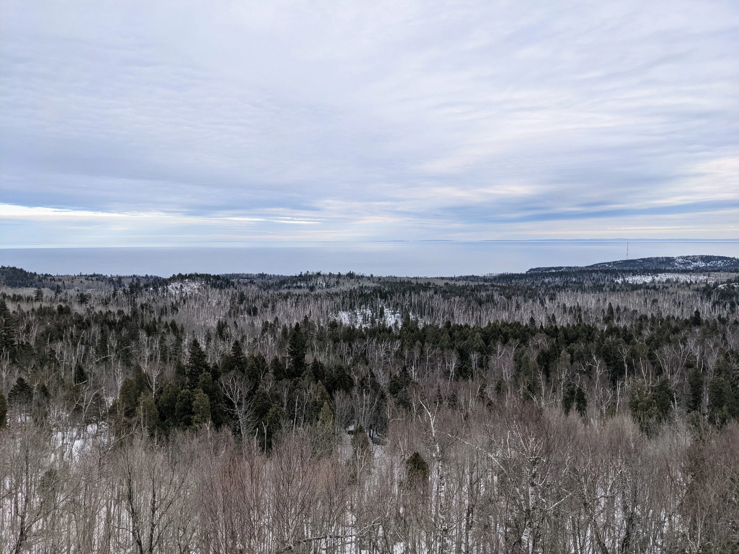
Lake Superior from the Superior Hiking Trail, Tettegouche State Park.
October 6th, 2023.
Lake Superior from the Superior Hiking Trail, Tettegouche State Park
March 16th, 2021
After descending the infamous drainpipe (a very steep and eroded rock staircase, followed by a long wooden staircase), the trail meanders back toward the Baptism River. I met a small group of backpackers who were just starting their trip, and we exchanged trail condition information, they were especially interested in the river crossing conditions at Split Rock.
All too soon, I arrived at the spur trail that led back to the trailhead parking lot. The SHT is detoured through Tettegouche State Park after flooding damaged the famous swinging bridge a few years ago.
I can’t wait to get back to the North Shore again, I think there will be a couple of trips this winter, and then the final segment, Gunflint Trail to 270 Degree Overlook, coming up in 2024. This is a special place, and I’m thankful for the opportunity to explore and travel through it. I started each day off with a little prayer that I think sums up the experience:
”Heavenly Father, thank you for this day, the air in my lungs, and the earth beneath my feet. Thank you for the ability to come here, experience this, and spend a few days surrounded by your natural creation. I am blessed, and I thank you.”
Thank you for reading my ramblings. I hope you have enjoyed!
Until next time, hike on!
-Scout
